
Info - Old St. Marys, Clonmel
Old St. Mary's Church and Graveyard
Map Co-ords: 52.354111, -7.705643
Old St. Mary's Church and graveyard is surely the jewel in the crown of Clonmel's historic sites.
The church dates back to the early 1200's, and it is likely that people were interred in the grounds from that time onwards. There is little to show of those early graves now, as the oldest headstone that is readable dates from 1625, that of a Jesuit, Nicholas Leynagh. There follows a gap until 1700, but from then on the dates on the headstones are regularly spaced.
The most recent interment was in 1958, in an existing grave, originally opened in 1855.
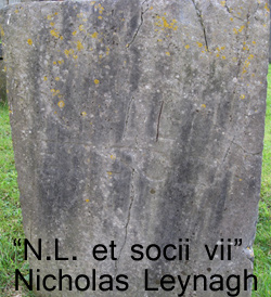
How often have we taken a stroll or shortcut through this graveyard, without stopping to read any of the headstone inscriptions, even those close to the main path. To do so, though, will reveal a wealth of information, almost a history of Clonmel from 1700 to the mid-1900's.
Browse through the records and you will find names of the many British Regiments and Militia who were stationed her and deployed whenever the 'pesky Irish' needed to be calmed down. You can read of tragedy, when even well-off Protestant families perished in famine times, though probably from fever rather than hunger. Read of how parents buried three or four, sometimes more of their children, all at tender ages.
There are solitary graves of the wives of soldiers, their husbands later transferred away, never to return to be laid to rest with their wives. Some graves have such lengthy and excessively exuberant inscriptions that stone carving must have been a well-rewarded trade in those times.
It's all here. Although it takes a little effort, do spend some time clicking through the records and you will hopefully be well rewarded. Even better, if you can, stroll through the headstones and see for yourself.
The actual layout of plots is uncertain, with rows never clearly delineated, forming wavy or curving lines across the grass. As far as I know, there is no grid reference system to help locate a particular grave. The "Sections" adopted in the layout map divide the site into rough blocks, and any record with a Section Number will be found - somewhere- within its section.
However, any records without a Section Number, also lack a headstone image to help identify the grave. This is because so many headstones are unreadable, for a variety of reasons, and could not be associated with the existing text records which were recorded several years ago.
Previous work done.
It is important to note that my work merely continues the sterling efforts of those volunteers, who in the late 1990's, went about recording the full inscriptions on these headstones. Time and grime continue to take their toll on the inscribed surfaces, so all efforts to preserve the data are to be welcomed.
This effort is dedicated to making the data available as a searchable database online, with as many images of the headstones included as is possible. Some errors in the original data have been found and corrected.